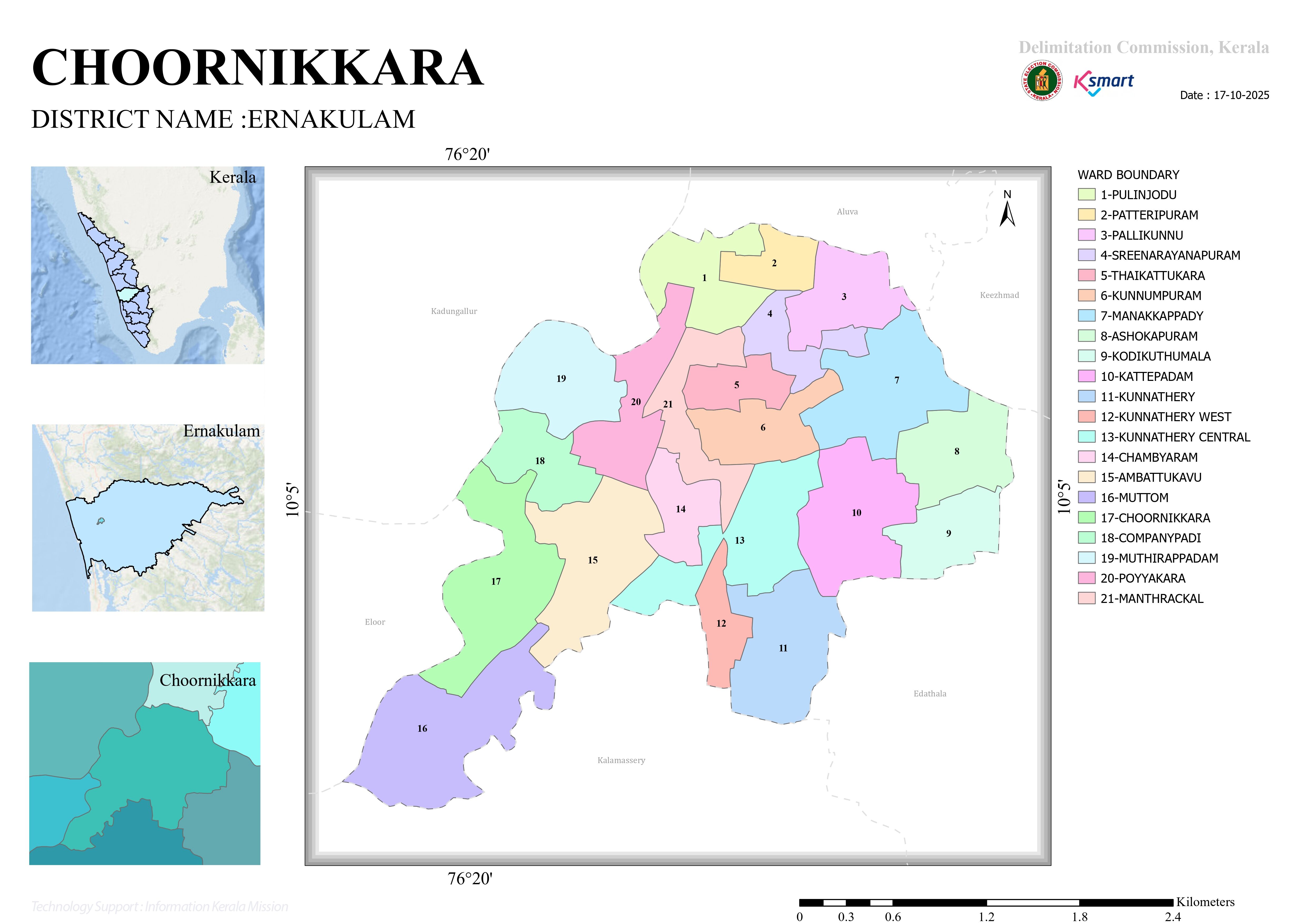
MAP
Choornikkara Grama Panchayat Ward Delimitation: Analytical Report
Based on the official order issued by the Kerala Delimitation Commission (Order No. SDC/516/2024/SDC1), the following analytical report presents the delimitation of electoral constituencies (wards) in Choornikkara Grama Panchayat, located in Ernakulam District.
Choornikkara Grama Panchayat Ward Delimitation: Analytical Report
1. Background and Order
As per the earlier notification issued by the Director of Local Self Government (Rural), the number of seats to be filled through direct elections in Choornikkara Grama Panchayat was fixed at 21.
Accordingly, under Section 10 of the Kerala Panchayat Raj Act, 1994, a committee comprising Chairman A. Shahjahan and members Rathan U. Khelkar, K. Biju, Harikishore S., and K. Vasuki determined the ward boundaries and issued this final order.
2. Key Findings
Number of Wards
Unlike the previous arrangement, Choornikkara Grama Panchayat has now been divided into 21 electoral constituencies (wards).
Population Balancing
An examination of the delimitation schedule indicates that the Commission made a significant effort to ensure a balanced population distribution among the wards. Most wards have populations ranging between 1,400 and 1,700 residents.
Ward with the Highest Population
Ward 19 – Muthirappadam: 1,726 residents
Ward with the Lowest Population
Ward 07 – Manakkappady: 1,321 residents
3. Wards and Population Details
Ward No. & Name | Population |
|---|---|
01. Pulinchode | 1,471 |
02. Patteripuram | 1,507 |
03. Pallikkunnu | 1,565 |
04. Sree Narayanapuram | 1,657 |
05. Thaikkattukara | 1,698 |
06. Kunnampuram | 1,687 |
07. Manakkappady | 1,321 |
08. Ashokapuram | 1,573 |
09. Kodikuthumala | 1,576 |
10. Katteppadam | 1,704 |
11. Kunnatheri | 1,540 |
12. Kunnatheri West | 1,410 |
13. Kunnatheri Central | 1,404 |
14. Champyaram | 1,468 |
15. Ambattukavu | 1,540 |
16. (Name Not Recorded) | 1,404 |
17. Choornikkara | 1,510 |
18. Companypady | 1,715 |
19. Muthirappadam | 1,726 |
20. Poyyakkara | 1,629 |
21. Manthrakkal | 1,640 |
Note: The name of Ward No. 16 is not specified in the available schedule, although its population is recorded as 1,404.
4. Geographical Characteristics of Boundary Delimitation
The Commission used major roads, canals, public institutions, and railway/metro infrastructure as primary reference points while defining ward boundaries.
Major Roads
The following roads serve as important ward boundaries:
National Highway 544 (NH 544)
PVIP Canal Road
Pipeline Road
Aluva–Munnar Road
NAD Road
Natural Boundaries
Several natural features play a major role in separating wards, including:
Periyar River
Muttar River
Purakkalippadam Canal
Kaithalippadam Canal
Katteppadam Canal
Kodungottu Canal
Urban and Neighbouring Administrative Boundaries
The order clearly demarcates boundaries adjoining:
Aluva Municipality
Kalamassery Municipality
Edathala Grama Panchayat
Additionally, portions of the Kochi Metro yard have been incorporated as reference points in the boundary determination process.
Conclusion
In response to population growth within Choornikkara Grama Panchayat, the Commission has completed a comprehensive redrawing of ward boundaries, creating 21 wards designed to ensure fair and democratic representation. The new delimitation reflects a balanced distribution of population, clearly defined geographical boundaries, and improved administrative efficiency. This revised ward structure is expected to strengthen local governance and facilitate more effective delivery of public services throughout the Panchayat.